Difference between revisions of "South American Supremacy"
(New page: South American Supremacy Variant Rules, Version 1.0. <br> See the homepage below for current RP files <br> [http://nairenvorbeck.angelfire.com/ Homepage:] [[Image:SASStart1.gif|center|...) |
|||
| (One intermediate revision by the same user not shown) | |||
| Line 10: | Line 10: | ||
by Benjamin Hester / Converted for Realpolitik by Ben Hines | by Benjamin Hester / Converted for Realpolitik by Ben Hines | ||
| + | |||
| + | [[Image:RuffSAS.gif|thumb|450px]] | ||
1. The Starting Year is 1835, though the map represents no | 1. The Starting Year is 1835, though the map represents no | ||
| Line 75: | Line 77: | ||
See the board game for more information on how to play | See the board game for more information on how to play | ||
Diplomacy. | Diplomacy. | ||
| − | |||
| − | |||
[[Category:Variant]] | [[Category:Variant]] | ||
Latest revision as of 14:45, 13 August 2009
South American Supremacy Variant Rules, Version 1.0.
See the homepage below for current RP files
Homepage:
Variant Description:
South American Supremacy
by Benjamin Hester / Converted for Realpolitik by Ben Hines
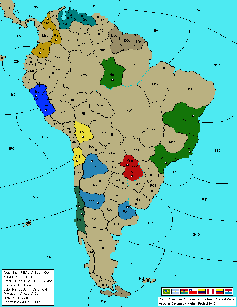
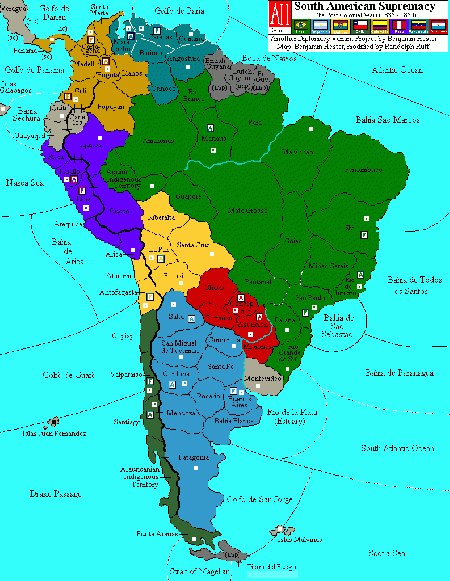
1. The Starting Year is 1835, though the map represents no exact period in time. Rather, the map and the variant as a whole are a composite of 19th century South America.
2. Starting Positions:
Chile: F Val, A San Argentina: F BAs, A Cor, A Sal Brasil: F SaP, A Rio, F Slv, A Man Bolivia: F Ant, A LaP Colombia: F Cal, F Car, A Bog Paraguay: A Asu, A Con Peru: F Lim, A Tru Venezuela: F Mar, A Ccs.
3. The Andes Mountains: Indicated by a darkened border, separating the western ridge of the continent from the interior. Units may not cross the Andes Mountains (like Switzerland) except at "passes," marked on the map by two small parallel lines with a normal border between them. The Andes Mountains form the border between Cali and Popayan, and stretch all the way south to separate Punta Arenas from Patagonia.
4. Punta Arenas/Tierra Del Fuego:
An army or a fleet may enter either of these territories, OR a fleet may pass directly from the Golfo de San Jorge to the South Pacific Ocean.
Adjacencies in the region are as follows:
GSJ borders TdF, Pat, ScS, Mal, and SPO via Magellan. (NOT PAs) TdF borders PAs, GSJ, Pat, ScS, SPO. PAs borders TdF, SPO, and Ara. (NOT Pat, because of the Andes, and NOT GSJ) SPO borders PAs, Ara, San, Val, Jua, GdG, ScS, TdF, and GSJ
5. Rivers: Very simple. The Amazon and Parana rivers are navigable by fleets. They are NOT separate bodies of water themselves. This means that fleets can move up and along these river borders just like fleets on coastlines can. For example, a fleet could on subsequent turns move from RdP to BAs to SaF to Crt to Asu to Mis to Prn, etc. etc. No special order format is needed. Support operates as normal, though it should be noted that fleets CANNOT support actions involving inland territories while on a river. Just as a Fleet in Belgium could not support an Army Burgundy into Ruhr, neither could a Fleet Santa Fe support an Army Cordoba into Rosario. Also, fleets may not convoy while on a river (just like fleets on a coastal territory may not convoy in standard.)
6. British, French, and Dutch Guyana: European controlled territories that are impassable like Switzerland.
7. Victory conditions, turn movement, and all other aspects of SAS conform to Standard in every way.
The rules to Diplomacy are copyright 1999, Hasbro, Inc.
See the board game for more information on how to play Diplomacy.

