Viking
Viking Diplomacy is a variant by Erlend 'Joe' Janbu.
Very special thanks to Rob Addison for very good help and advice on
the design, and for making the map so beautiful.
Also thanks to Cristiano Corte Restitutti for lots of input on the Dark Age aera. Let me also thank Benjamin Hester, William Simonitis, Ian Cowburn and Frank Johansen for their input.
Variant Description
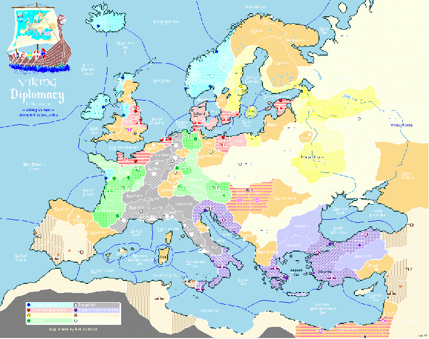
Hedeby is a channel province, just like Kiel in standard.
Oerne(and Kalmar) is a channel too, and armies can move to Kalmar, Jylland and Hedeby without convoy.
Fleets in the waterways labelled "Volga route" and "Dnepr route" may convoy armies. The armies can only be convoyed along the waterway, not across the river (e.g. a fleet in Gardarike may convoy an army from Kjonugard to Holmgard, but not from Smolensk to Mordvin).
The neutrals with a brighter center are holding neutrals. These neutrals are Buda, Pest, London, Jorsal and Alexandria. They order: A Lon H, A Bud s A Pes, A Pes s A Bud, A Jrs s A Ale. If dislodged, they retreat off the board. They will only do the support if they unit they support is a holding neutral as well. If a holding neutral is dislodged in spring, but the invader vacates in fall, a new holding neutral army will be rebuilt.
Victory conditions are 26 centers. If two or more players occupy 26 centers or more during the same year, any one of those may choose to declare the game a draw between the players who owns more than 25 centers. Until any player does this, the game goes on until only one player owns 26 centers or more.
A note about the powers: Largely, the variant reflects the situation around 950 AD. However, a few liberties has been taken, to provide the map with 8 playable great powers. West and East Francia was adjoined to "France", and Lothringen, Burgundy and Lombardia has been adjoined in one power. The Arab Caliphates were in control of Egypt and modern Israel, but I found it would be interesting to have a self-defending neutral there. The Slavic Nations were not united, but to give the Swedish Vikings opposition in the east, their unification is necessary. I believe Normandie (the Rouen territory) is at its largest state, but on Great Britain, the areas marked light blue and red were the primary settlements, while larger areas has been held in periods. Another clear liberty is marking Dorestad as the territory of western Netherlands, as if it was to be represented accurately, probably it would have the size of the dot. I doubt you would want to try to place units on that territory, though! The same goes for the neutral Gothenburg. The interior parts of the province belonged to Sweden, the coast north of the city to Norway and the coast south of the city to Denmark. Merely the city was invaded and bought back and forth. Still, there is no room for a unit on a 2 pixel radius territory.
